Solstice, equinox, and seasons
Calculating Earth's circumference using Eratosthenes method during the solstice
What are the solstices?
The word "solstice" originates from two Latin words "sol" (sun) and "stitium" (pause or stop). It means the the time or point that the sun's yearly journey in the sky, is either at its highest, ascending, or lowest, descending.
The winter solstice occurs when the sun reaches its shortest and lowest arc.
North of the equator the winter solstice typically falls between December 20 and 23. this also means the length of day is the shortest of the year and marks the beginning of winter. Then, the Sun begins its ascent, which will gradually lengthen the day light each days until late June.

However, in the Southern Hemisphere, the length of day light is the longest of the year and marks the start of summer. Then, the Sun begins its descent, which will gradually shorten the day light each day until late June.
The position of the Sun in the sky of the Northern Hemisphere's winter solstice, is at its lowest in the sky because the upper half of the Earth is at its most tilted position away from the sun, resulting in the shortest day and longest night of the year.
Conversely, the position of the Sun in the sky of the Northern Hemisphere's summer solstice, is at its highest in sky because the upper half of the Earth is tilted towards the sun, resulting in the longest day and shortest night of the year. This solstice occurs between June 20 and 22.
Thus, December 21st marks the shortest day of the year north of the equator, where it is the beginning of winter. And, it's the longest day of the year in the Southern Hemisphere, and the start of summer.
Throughout history, people have commemorated solstices with various celebrations and monuments, such as Stonehenge, which was designed to align with the Sun's paths during celestial events.
What is an equinox?
During the equinox, the Earth's axis and its orbit align, ensuring that both hemispheres receive an equal amount of sunlight.
The term "equinox" derives from two Latin words, "aequus" (equal) and "nox" (night). This is because, on the equinox, day and night span nearly the same duration, although there may be slight variations depending on the location on the planet.
In the Northern Hemisphere's fall, or autumnal, equinox occurs between September 21 and 24, varying each year. On the other hand, the spring, or vernal, equinox falls between March 19 and 21.
Seasons
Beyond solstices and equinoxes, there are two distinct methods for dividing the year. While astronomical seasons are determined by the Earth's orbit around the sun, meteorological seasons are defined by weather patterns.
Meteorologists categorize the year into three-month seasons based on annual temperature fluctuations. According to this calendar, spring begins on March 1, summer commences on June 1, fall starts on September 1, and winter concludes on December 1.
Eratosthene's
Eratosthenes, a Greek geographer (about 276 to 194 BCE), made a surprisingly accurate estimate of the Earth's circumference.
How did he do it?
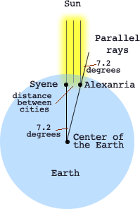
In the great library in Alexandria, Egypt, he read that there was a deep vertical well near Syene, in southern Egypt, that was entirely lit to the bottom of the well by the sun at noon once a year: summer solstice. Eratosthenes understood if the sun is directly overhead, its rays would shin straight down into the well and lite the bottom.
Solstice happens two times a year, Summer Solstice and the Winter Solstice. A solstice is when the Sun is at its highest or lowest point in the sky at noon. Which makes the longest and shortest days (about June 22 and December 20). Caused by the Sun's motion, being the longest or shortest path across the sky.
The Tropic of Cancer is north of the Equator at 23.4372° latitude. It is the latitude where once a year the sun is directly overhead: Summer Solstice.
The Tropic of Capricorn is south of the Equator at -23.4372° latitude. It is the latitude where once a year the sun is directly overhead: Winter Solstice.
Equinox is the day (twice each year) when the sun crosses the celestial equator, when day and night are of equal length (about September 22 and March 20).
Eratosthenes, understood the movement of the Sun across the sky. He knew in Alexandria, Egypt the sun was not directly overhead at noon on summer solstice because vertical objects there cast a shadow. He knew that Alexandria was 5000 stadias almost due north of Syene, Egypt. And he understood enough geometry to reason he could use this information to calculate the circumference of the Earth.
Assumptions:
- He assumed: the Earth was round (sorry Columbus).
- The sun's rays traveled in a straight line. And
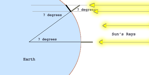
- The rays both places were essentially parallel.
Data:

He set up a vertical post at Alexandria and measured the angle of its shadow at summer solstice (7.2 degrees), when the well at Syene was completely sunlit, which meant the sun was vertically over the well.
Reasoning:
- From geometry, Eratosthenes knew, the angle of the shadow at Syene equaled the angle at the earth's center between Syene and Alexandria. A line crossing parallel lines will have the same angles.
- The arc of an angle this size was, therefore, 1/50 of a circle (360° / 7.2° ≈ 50). Based on 360° assumption of a round earth.
- The distance between Syene and Alexandria was 5000 stadias.
- So he multiplied 5000 by 50 to find the Earth's circumference.
- His result, 250,000 stadias (about 46 250 km) is quite close to modern measurements (40 075 km at the equator).

Source Investigating the Earth, AGI, 1970, Chapter 3, p. 66.

The formula Eratosthenes used:
(360° / shadow angle of vertical stick) * distance from Syene to Alexandria = Circumference of the Earth
Formula you can use to calculate circumference of the Earth.
(360° / shadow angle of vertical stick) * distance from Syene = Circumference of the Earth
Syene is located on or near the Tropic of Cancer (23.5° N), where the Sun would be overhead on the Summer Solstice.
- The Sun is directly overhead of the Tropic of Cancer (23.5° N) on Summer solstice,
- Overhead of the Tropic of Capricorn (23.5° S) on Winter Solstice
- Overhead of the Equator (0° N) on Spring and Fall and Equinoxes.
Use these ideas to determine the Earth's circumference.
- On the Summer Solstice place a vertical stick into the ground.
- When the sun reaches it's highest vertical assent for the day (solar noon therefore the shadow length will be the shortest), measure the angle of the shadow (shadow angle of a vertical stick).
(360° / shadow angle of vertical stick) * distance from Tropic of Cancer = Circumference of the Earth
On the equinox, the vertical rays of the sun are directly over the equator. How would you calculate the circumference of the Earth using the same method during an equinox?
How about sharing shadow angle measurement with others around the real globe. Contact others that would be willing to collect the same data and exchange it possibly using the following format.
Date of measurement ____________
Your measurement of the shadow angle ____________ degrees
Your location city ____________________________________
Your location country _________________________________
Your latitude _________________________________________
Your longitude ________________________________________
When you have different sets of data compile them and compare the various locations and angles.